When you own a piece of land or property in New Zealand, you might find yourself asking:
“What can I do with my site? What are my development options?”
Crafting a land development plan is the best way to answer these questions. A land development plan is essentially a roadmap for turning your land into its best possible use. By carefully assessing your site’s characteristics, understanding local regulations, and exploring various strategies, you can identify the optimal development options for your land. In this guide, we’ll explain how to evaluate your property and outline potential development paths, all in the context of New Zealand’s planning rules and best practices.
Understanding Why You Need Land Development Plans
A land development plan is a comprehensive strategy that outlines how a piece of land will be developed, including what can be built, where it can be positioned, and what steps are needed to make it happen. Think of it as a blueprint for your project’s success. Creating a thorough development plan before you break ground is crucial because it helps prevent costly mistakes and delays. It forces you to consider key components like site layout design, infrastructure needs, and regulatory compliance from the start. Skipping the planning stage or rushing through it can lead to miscommunication, expensive changes down the line, or even legal issues if you overlook important rules. In short, a well-thought-out plan sets a solid foundation for a smooth project.
A land development plan helps streamline the entire development process by identifying challenges and requirements early. It also balances your goals with practical considerations. For example, you may wish to maximise the number of houses on your property, but you must also ensure the end result is livable, aesthetically pleasing, and compliant with building regulations. By investing time in planning, you can strike the right balance between your vision and what’s feasible for your site. Moreover, having a documented plan is often necessary when working with professionals (like architects, surveyors, and engineers) and when seeking approvals from council.
At Fluker Surveying, we strongly believe in thorough planning. Our team often helps clients with feasibility studies and concept plans to determine the best way forward. Early feasibility assessments look at factors like zoning, land size, topography, and access to services to tell you what’s realistically possible on your site. By doing these checks upfront, you avoid pursuing ideas that won’t work and focus on options that do. Remember, every property is unique.
Checking Your Zoning and Council Rules
Zoning rules decide what you can build on your land. Every property in New Zealand falls under local planning rules, like the District Plan or Auckland Unitary Plan, which set out permitted uses, building height, density, setbacks and more.
Start by checking your property’s zoning using your council’s online map or GIS tool. In Auckland, the Unitary Plan Viewer makes this easy.
For example, Mixed Housing Suburban and Urban zones usually allow up to three homes per site if you meet the standards. Single House zones typically permit only one dwelling unless you get resource consent. More intensive zones, like Terrace Housing, allow higher density but come with stricter requirements.Know your zone, understand the rules, and plan accordingly.
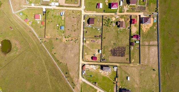
Analysing Site Constraints and Features
Every site has unique features that can affect development options. A smart development plan takes into account the physical characteristics and constraints of your property:
- Property size and shape: The size and layout of your land affect how many homes you can build and where. Larger or corner sites offer more options, while narrow or odd-shaped lots may limit layout. Councils also set minimum lot sizes and site coverage rules.
- Topography and terrain:Sloped or uneven land may need earthworks, retaining walls or special foundations. A topographical survey helps map contours and plan for drainage and access.
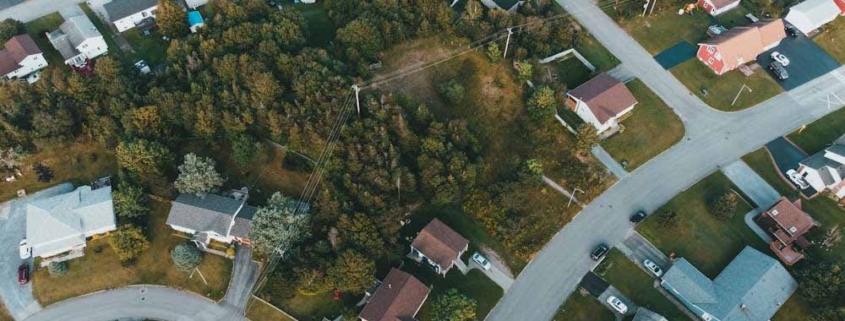
- Existing structures or features: Any existing buildings or trees must be factored in. You’ll need enough space for new dwellings to meet spacing and sunlight rules. Sometimes removing or shifting buildings opens up more usable land.
- Underground utilities and services: Check for pipes and cables under or near the site. These can limit where you build. Development must connect to services like water and power, and some areas may need upgrades or consents due to capacity limits.
- Hazards and environmental constraints: Flood zones, erosion risks or protected features can restrict development. You may need elevated floors or special designs, and consents are often required.
Given all these variables, a site analysis by professionals is invaluable. A professional site assessment maps out buildable areas, checks boundaries and identifies risks. It’s a key step to avoid costly surprises and make the most of your land.
Exploring Development Options
Once you’ve done your homework on zoning and site conditions, consider specific development options. The best option depends on your goals (e.g., creating an investment to sell versus expanding your family home) and the constraints we discussed. Common development routes in New Zealand include:
Build an Additional Dwelling (or Two)
Adding a second or third home can boost value or house extended family. This could be a minor unit or a full home, often allowed in residential zones if standards are met (e.g., access, sunlight, outdoor space). Resource consent investigation may still be needed to confirm compliance or manage minor rule breaches.
Subdivision of the Land
Subdividing splits your land into separate titles. It’s a common way to unlock value and can be paired with new builds or done alone. Each lot must meet size, access and service requirements. The process involves resource consent, a licensed surveyor, and final council approval to issue new titles.
Multi‑Unit Development or Apartments
If your zoning allows, you could build several townhouses or apartments. This maximises land use but requires good design and more detailed consents. You’ll need professionals to manage layout, infrastructure and council requirements. Done well, it can offer strong returns.
Renovation or Extension of Existing Structures
Sometimes the best option is improving what’s already there. You could modernise and extend an existing home, add a granny flat or repurpose part of the land with a detached garage or studio. This may not create additional lots, but it can add value and functionality. Even extensions and accessory buildings need to comply with planning rules and may require building consent. This path is simpler than building new houses but yields a smaller scale of change.
Changing Land Use or Rezoning
Some sites may suit a different use, like rezoning rural land for urban housing or converting a house to a commercial space. This process is complex, costly and slow, usually suited to large or strategic projects. Planning consultants are essential if you go this route.
Each of these options has pros and cons, and they’re not mutually exclusive. You might subdivide and build, or renovate while planning a future development. A clear development plan should show layout, required consents and next steps.
Navigating the Approval Process
No matter which development path you choose, you’ll likely need to engage with the local council approval process. This typically means applying for one or more resource consents (under the Resource Management Act) and, for construction, building consents (under the Building Act). A comprehensive plan will prepare you for these steps by identifying all required consents early.
Resource Consent
A resource consent is council approval to use land in a way that isn’t automatically allowed. Common types include land use consents (for extra dwellings or multi-units) and subdivision consents (to create new titles). Even in growth zones, consents are often needed to manage design, traffic, and infrastructure impacts. Councils assess effects on neighbours and services before approving, often with conditions. A complete, well-prepared application is key to avoiding delays, so it’s smart to involve planners or surveyors.
Engineering Approvals
For larger developments or subdivisions, specific engineering sign‑offs may be needed. This includes engineering plan approval for new infrastructure like driveways, drainage systems or road upgrades. Councils want to see that new services or physical works meet their standards. Subdivisions typically require detailed plans for utilities, earthworks and stormwater management. Any work on public assets (e.g., connecting to a sewer main) requires permits. Coordination with engineers early in the process ensures the design will satisfy council expectations.
Building Consent
Separate from planning consent, building consent ensures your construction meets building codes for safety and durability. Each new house or structure needs a building consent before construction. Your development plan should factor in time for this consent and inspections. Typically, you submit detailed architectural and structural plans after the resource consent stage to obtain building consent. Some councils allow parallel processing to save time.
Other Permissions
Don’t forget other potential requirements, such as resource consents for earthworks if you need major excavation and fill, discharge consents for drainage in sensitive areas or approvals from utility companies. If your site has an overlay like a heritage listing or coastal erosion zone, there could be additional hoops like heritage assessments or coastal engineer input. All of these should be identified in your planning stage so you’re not caught off guard later.
Starting Your Project: Get Professional Guidance
Turning a development idea into reality requires juggling many factors – design, regulations, engineering and finance. The good news is you don’t have to do it alone. Most successful projects involve a team of professionals:
- Licensed Cadastral Surveyor: Essential if you plan to subdivide or need to verify boundaries. Surveyors also provide topographical surveys and site measurements. At Fluker Surveying, our licensed surveyors ensure your boundary lines are correctly identified (preventing mistakes like building on a neighbour’s land) and can handle surveying work required for new titles and council certifications.
- Urban Planner / Planning Consultant: A planner interprets council rules and prepares resource consent applications. They make sure your development plan aligns with the District or Unitary Plan policies and help address environmental effects. Their expertise is invaluable in navigating the process and advocating for your project with council. Fluker Surveying offers land development planning services and can act as your planning consultant.
- Architect or Architectural Designer: Especially for multi‑unit developments or to maximise a small site, a good designer creates building plans that use space efficiently and comply with rules like height limits and daylight access. Thoughtful design can sometimes avoid the need for consent by staying within permitted standards or make the consent process smoother by demonstrating quality outcomes.
Working with professionals may seem like an added expense, but their expertise saves you time and prevents costly errors. They also help coordinate between disciplines (surveying, engineering and design) so that your project runs smoothly from concept to completion.
Maximising Your Land’s Potential
If you’re unsure about the next steps for your site, consider reaching out to our team at Fluker Surveying. With decades of experience in Auckland land development, surveying, engineering and project management, we can guide you from the initial feasibility study all the way to the final sign‑off. We’ve helped property owners across New Zealand turn a patch of empty land or a backyard with potential into thriving new homes and investments. We’d be happy to discuss your ideas, assess your site’s development potential and assist with crafting a solid plan moving forward.
Get in Touch
FAQs: Land Development Plans in NZ
What is a land development plan?
It’s a strategic plan or roadmap for developing a specific piece of land. It outlines what you intend to do (e.g., subdivide, build houses), how it will be laid out and what steps are needed (including consents, infrastructure and design considerations). It combines site analysis, feasibility study and project planning into one document.
How do I find out my property’s zoning and rules?
You can find your zoning on your local council’s website or district plan maps. For example, Aucklanders can use the Unitary Plan Viewer to see zoning and overlays for their address. If you’re elsewhere, search your city or district council’s website for planning maps. Planning consultants or surveyors can help interpret the rules if they’re confusing.
Do I need resource consent to add another house to my site?
It depends on your zoning and what you plan to do. In some zones, you can have up to a certain number of dwellings as of right (e.g., up to three per lot in some Auckland residential zones if all standards are met). However, even then you may need a land use resource consent to confirm you meet conditions or if there are minor infringements (like a building slightly closer to a boundary than allowed). For subdivisions, a resource consent is always required. Always check the specific rules or consult a professional.
What are common constraints that can affect development?
Constraints include minimum lot size (if subdividing), height limits, boundary setbacks and site coverage limits set by zoning. Physical constraints include steep slopes, unstable soil, flood zones, protected trees or services running through the site. These factors don’t necessarily stop development, but your plan must address them properly.
How can a professional help with my land development plan?
Professionals bring expertise that saves time and prevents costly errors. A surveyor accurately maps your site and marks boundaries. A planner understands council rules and prepares consent applications. Engineers ensure your development is physically possible and meets technical requirements.